| This is a documentation subpage for Template:Infobox Nepal municipality. It contains usage information, categories and other content that is not part of the original template page. |
This template is a customized wrapper for {{Infobox settlement}} and as such included in Category:Templates calling Infobox settlement. Any field from {{Infobox settlement}} can work so long as it is added to this template first. It will also emit the same hCard and Geo microformats as {{Infobox settlement}}. Questions? Just ask here or over at Template talk:Infobox settlement. |
Usage
{{Infobox Nepal municipality
| name                          = <!--Do not add the word "Municipality" -->
| nickname                      =
| native_name                   =
| native_name_lang              =
| motto                         =
<!-- image, map-->
| image_skyline                 =
| imagesize                     =
| image_alt                     =
| image_caption                 =
| map                           =
| mapsize                       =
| map_alt                       =
| map_caption                   =
| map1                          =
| mapsize1                      =
| map_alt1                      =
| map_caption1                  =
<!--pushpin, coord, geo-->
| pushpin_province              = <!--for a map of province (Nepal map automatically show)-->
| pushpin_mapsize               =
| pushpin_map_caption           =
| pushpin_label_position        =
| pushpin_relief                =
| coordinates                   =
| coordinates_footnotes         =
| province                      =
| district                      =
| ward                          =
<!--established, headquarters-->
| established                   =
| incorporated_vdc              =
| incorporated_date             =
| hq, headquarters or seat      =
<!--government-->
| government_footnotes          =
| mayor                         =
| mayor_party                   =
| deputy_mayor                  =
| deputy_mayor_party            =
| parliamentary_constituency    =
| mp_name                       = <!--mp=Member of parliament-->
| mp_party                      =
| provincial_constituency       =
| mla_name                      = <!--mla=Member of legislative assembly-->
| mla_party                     =
<!--area-->
| area_magnitude                =
| area_footnotes                =
| area_total_km2                =
| area_note                     =
| area_rank                     =
<!--elevation-->
| elevation_footnotes           =
| elevation_m                   =
| elevation_min_m               =
| elevation_max_m               =
<!--population-->
| population_footnotes          =
| population                    =
| population_as_of              =
| population_density_km2        =
| population_note               =
| population_rank               =
| households                    =
<!--others-->
| ethnicity                     = <!-- ethnic group-->
| female_percent                =
| male_per_100_female           =
| income                        =
| poverty                       =
| literacy                      =
| life_expectancy               =
| languages                     =
| highways                      =
| postal_code                   =
| area_code                     =
| website                       =
| footnotes                     =
}}
Example
Triyuga
त्रियुगा नगरपालिका | |
|---|---|
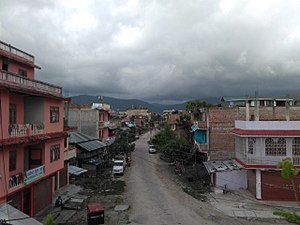
 View of a street in Purano (old) Gaighat, ward no. 11 | |
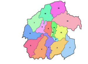
 Ward divisions of Triyuga | |
| Lua error in Module:Location_map at line 408: Malformed coordinates value. | |
| Coordinates: Lua error in Module:Coordinates at line 492: attempt to index field 'wikibase' (a nil value). | |
| Country | Nepal |
| Province | Province No. 1 |
| District | Udayapur |
| No. of wards | 16 |
| Established | 26 March 1997 |
| Incorporated (VDC) | Gaighat, Deuri, Bhumrasuwa, Jogidaha, Saune, Khanbu and Jalpachilaune |
| Incorporated (date) | 1997 & 2017 |
| Admin HQ. | Gaighat |
| Government | |
| • Type | Mayor–council |
| • Body | Triyuga Municipality |
| • Mayor | Advocate Mr. Baldev Chaudhary (NCP) |
| • Deputy Mayor | Mrs. Devi Chaudhary (NC) |
| • MP & Constituency | Udayapur 1 Dr. Narayan Khadka (NC) |
| • MLA & Constituency | Udayapur 1(B) Himal Karki (NC) |
| Area | |
| • Total | 547.43 km2 (211.36 sq mi) |
| • Rank | 1st in province 3rd in Nepal |
| Population (2011) | |
| • Total | 87,557 |
| • Rank | 5th in province 26th in Nepal |
| • Households | 19,484 |
| Demographics | |
| • Ethnic Groups | Chhetri, Tharu, Rai, Magar |
| Time zone | UTC+05:45 (NPT) |
| Postal Codes | 56300 |
| Telephone Code | 035 |
| Main Language(s) | Nepali, Tharu, Sunuwar/Kiranti, Maithili, Magar, Gurung |
| Website | www.triyugamun.gov.np |
{{Infobox Nepal municipality
| name                          = Triyuga
| nickname                      =
| native_name                   = त्रियुगा नगरपालिका
| native_name_lang              =
| motto                         =
<!-- image, map-->
| image_skyline                 = Purano Gaighat-11.jpg
| imagesize                     = 300
| image_alt                     =
| image_caption                 = View of a street in Purano (old) Gaighat, ward no. 11
| map                           =  Triyuga municipality divisions.png
| mapsize                       = 300
| map_alt                       =
| map_caption                   = Ward divisions of Triyuga
| map1                          =
| mapsize1                      =
| map_alt1                      =
| map_caption1                  =
<!--pushpin, coord, geo-->
| pushpin_province              = Nepal Province1
| pushpin_mapsize               = 300
| pushpin_map_caption           = Location in Province No. 1
| pushpin_label_position        =
| pushpin_relief                =
| coordinates                   = {{coord|26|47|31|N|86|41|56|E|region:NP-BR|display=inline,title}}
| coordinates_footnotes         =
| province                      = [[Province No. 1]]
| district                      = [[Udayapur District|Udayapur]]
| ward                          = 16
<!--established, headquarters-->
| established                   = 26 March 1997
| incorporated_vdc              = [[Gaighat, Nepal|Gaighat]], Deuri, Bhumrasuwa, [[Jogidaha]], [[Saune]], [[Khanbu]] and [[Jalpachilaune]]
| incorporated_date             = 1997 & 2017
| hq      = [[Gaighat, Nepal|Gaighat]]
<!--government-->
| government_footnotes          =
| mayor                         = Advocate Mr. Baldev Chaudhary
| mayor_party                   = [[Nepal Communist Party|NCP]]
| deputy_mayor                  = Mrs. Devi Chaudhary
| deputy_mayor_party            = [[Nepali Congress|NC]]
| parliamentary_constituency    = [[Pratinidhi Sabha|Udayapur 1]]
| mp_name                       = [[Narayan Khadka|Dr. Narayan Khadka]]
| mp_party                      = [[Nepali Congress|NC]]
| provincial_constituency       = [[Provincial Assembly of Province No. 1|Udayapur 1(B)]]
| mla_name                      = Himal Karki
| mla_party                     = [[Nepali Congress|NC]]
<!--area-->
| area_magnitude                =
| area_footnotes                =
| area_total_km2                = 547.43
| area_note                     =
| area_rank                     =1st in province<br/>3rd in Nepal
<!--elevation-->
| elevation_footnotes           =
| elevation_m                   =
| elevation_min_m               =
| elevation_max_m               =
<!--population-->
| population_footnotes          =
| population                    = 87,557
| population_as_of              = 2011
| population_density_km2        =
| population_note               =
| population_rank               = 5th in province<br/>26th in Nepal
| households                    = 19484
<!--others-->
| ethnicity                     = [[Chhetri]], [[Tharu people|Tharu]], [[Rai people|Rai]], [[Magar people|Magar]]
| female_percent                =
| male_per_100_female           =
| income                        =
| poverty                       =
| literacy                      =
| life_expectancy               =
| languages                     = [[Nepali language|Nepali]], [[Tharu language|Tharu]], [[Sunuwar language|Sunuwar]]/[[Kiranti language|Kiranti]], [[Maithili language|Maithili]], [[Magar language|Magar]], [[Gurung language|Gurung]]
| highways                      =
| postal_code                   =56300
| area_code                     =035
| website                       = [http://www.triyugamun.gov.np www.triyugamun.gov.np]
| footnotes                     =
}}
Microformat
The HTML mark up produced by this template includes an hCard microformat, which makes the place-name and location parsable by computers, either acting automatically to catalogue article across Wikipedia, or via a browser tool operated by a person, to (for example) add the subject to an address book. For more information about the use of microformats on Wikipedia, please see the microformat project.
If the place or venue has an "established", "founded", "opened" or similar date that is specific to the day, use {{start date}} unless the date is before 1583 CE. If it has a URL, use {{URL}}.
hCard uses HTML classes including:
- adr
- category
- country-name
- extended-address
- fn
- label
- locality
- nickname
- note
- org
- street-address
- url
- vcard
Please do not rename or remove these classes nor collapse nested elements which use them.